During construction
We will minimise our impact on communities as much as possible. To help us do this, we have signed up to the highest construction standards through our Code of Construction Practice (PDF 1.3MB).
Watch our new fly-through to see the proposed road during construction.
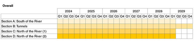
If our DCO is granted, we intend to start construction of the new road in 2024. Our target road opening is 2029/30, but for the purposes of construction and traffic modelling the road opening date is assumed to be 2029 throughout this consultation.
The construction works would be divided into four sections to help make sure they are delivered on time and with the minimum impact on local communities, the environment and road users:
- Section A: south of the Thames in Kent, to include works along the M2/A2 corridor, the proposed junction with the M2/A2, and all other carriageway works as far as (and including) the proposed Thong Lane North Bridge over the new road.
- Section B: to the north of Thong Lane North Bridge, as far as the proposed Tilbury Viaduct. This includes the works to build the tunnel and its approaches south and north of the Thames.
- Section C: from (and including) the proposed Tilbury Viaduct, as far as (and including) Green Lane, north of the proposed A13/A1089 junction with the new road.
- Section D: north of Green Lane, to include works through the Mardyke Valley, along the M25 corridor and around junction 29 of the M25.
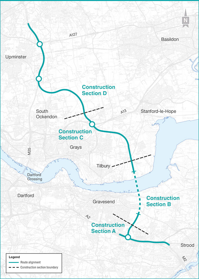
Map of construction sections
Construction programme
Work in each section would typically cover three main phases of work:
- initial works, including setting up the construction compounds
- main works, covering the construction of the highways north and south of the Thames and all elements of the tunnels and their approaches, as well as utilities and environmental mitigation works
- testing and commissioning, where we make sure the new road and its infrastructure is safe and ready for use
Planned construction programme for the project
Work would include:
- tunnelling
- earthworks
- building retaining walls
- road resurfacing and widening works
- culverts, drainage works and flood compensation
- removing topsoil and temporary soil storage
- management of excavated material and earthworks
- drainage and flood compensation
- bridge and viaduct construction
- temporary lighting
- site fencing and hoarding
- installation of gantry and signage foundations
- tie-in and finishing works
More information on construction methods used to build the Lower Thames Crossing, including associated structures such as bridges and viaducts, please refer to the Construction update in our document library.
Section A would include:
offline works north of the A2/M2, involving:
- excavating a large area of land north of the A2/M2, so that the new road can be built into it and approach the southern tunnel entrance at an appropriate depth
- building a new junction with the A2/M2, involving two new viaducts and extensive ecological planting to offset any negative impacts
Gravesend East junction
- the existing junction would need to be modified, with changes to the roundabout, the widening of a bridge, new retaining walls and roadside infrastructure including lighting
- connector roads around the A2/M2
- building new green bridges (linking habitats for wildlife, as well as connections for walkers, cyclists and horse riders) at Thong Lane and Brewers Road
- works affecting other local roads, including Halfpence Lane
- decommissioning and removing the Cobham service station
To learn more about works in Section A and their impacts, please go to chapter 3 of the Construction update (PDF 37.3MB).
Section B would include:
tunnel compound set‑up
- building and preparing two large compounds north and south of the Thames for the tunnel boring machines to be assembled, launched and later disassembled for removal
- setting up two smaller compounds south of the Thames
ground protection tunnelling and strengthening works
- building a shorter tunnel beneath a section of land south of the Thames so that we can strengthen the ground through which the main tunnels would be built
launch structure and approach ramp
- excavating the land needed north of the Thames to launch the tunnel boring machines and, once that has happened, preparing the same land so that we can build the section of road that connects Section A to the tunnel entrance
tunnelling and fit‑out
- preparing the bored tunnels for use as roads, including the assembly of concrete segments, laying the road and building cross‑passages between them
earthworks and landscaping
- using or removing the significant quantities of earth that would be generated by the tunnel boring machines and other works needed to build the tunnel entrances and approach roads
To learn more about works in Section B and their impacts, please see chapter 4 of the Construction update. Please see the Ward impact summaries for more information on the impacts of construction and their mitigations in Section B.
Map of construction sections
Section C would include the following:
Tilbury Viaduct
- building a new viaduct to carry the new road over the Tilbury Loop railway line
Chadwell St Mary link
- building new bridges to carry Muckingford Road, Brentwood Road and Hoford Road over the new road
- building the new road from the new Tilbury viaduct to its junction with the A13
A13 junction
- building a new underpass beneath the existing A13/A1089 junction
- replacing the current bridge carrying Rectory Road over the A13
- realigning Stanford Road (A1013), requiring the construction of three new bridges
- building the Orsett Heath viaduct, which would pass over Baker Street and the A1089
- replacing the existing bridge at Baker Street and the realignment of Baker Street
- realigning Heath Road by around 250 metres further to the south
- relocating the existing Gammonfields traveller site to a nearby location
- realigning Stifford Clays Road and building two new bridges to carry the road over the Lower Thames Crossing
- realigning Green Lane and building a new green bridge
- building new roads and infrastructure to connect the Lower Thames Crossing to the A13 and Orsett Cock junction
To learn more about works in Section C and their impacts, please go to chapter 5 of the Construction update (PDF 37.3MB).
Map of construction sections
Section D would include:
Ockendon link
- building the section of road connecting the A13 junction with the M25
- building two new viaducts in the Mardyke area so that the new road can safely pass over the floodplain
- building a new bridge to carry North Road over the Lower Thames Crossing, involving the temporary realignment of North Road
Lower Thames Crossing/M25 junction
- building temporary slip roads between our worksite and the M25 for direct access
- building an underpass for the northbound Lower Thames Crossing to pass beneath the M25
- building a new bridge to carry Ockendon Road over the new road
M25 widening, including M25 junction 29
- widening the road to manage the changes to traffic flows that the Lower Thames Crossing is likely to generate
- widening St Mary’s Lane and Shoeburyness railway line bridge
- increasing the M25 main carriageway to four lanes at junction 29
Map of construction sections
Compounds and hubs
It’s likely we would need 18 compounds and 16 Utility Logistics Hubs to support construction, located away from environmentally sensitive areas and local communities wherever possible.
However, they would need to service specific areas along the project route and provide access for staff and materials, so some would be near towns or villages.
Utilities
Along the proposed Lower Thames Crossing, there are a number of existing utilities including overhead power lines, high-pressure gas pipelines, electric cables and substations, gas mains, water pipes, sewers and fibre-optic and telecoms cables that would need to be diverted to build the new road.
Our proposals for utility works have evolved during the project’s design and development. We have been working closely with the utility companies to significantly reduce the environmental impacts and shorten the duration of the works. There should be no disruption to the supply of power, water or any other utilities caused by our construction work.
For more information on the planned utility works, please see chapter 2 of the Construction update (PDF 37.3MB).
When we apply to the Planning Inspectorate for permission to build the new road, we will provide a range of documents that set out how we would make sure our appointed contractors effectively manage the potential impacts of construction on the environment and local communities. Drafts of these control documents are part of this consultation.
They include:
- the Code of Construction Practice and another related document
- the Register of Environmental Actions and Commitments (REAC)
- several others dealing with specific topics
If we are granted permission to build the new road, the control documents would be developed further by our contractors. Once agreed upon, those contractors would have legal obligations to comply with the conditions they contain.
Control documents are discussed in more detail in chapter 1 of the Construction update (PDF 37.3MB).
The construction of the project would have an impact on the performance of the highway network and journey times for many people travelling in the area
Construction-related vehicles
The number of Heavy Goods Vehicles (HGVs) on public roads would increase. These would be used to deliver materials to the various construction compounds and Utility Logistics Hubs (ULHs). (Chapters 3-6 of the Construction update (PDF 37.3MB) describe the location of these compounds and ULHs, and the access routes HGVs would take.)
These routes are designed to make the maximum use of the Strategic Road Network, and the project’s HGVs would be banned from using certain local roads. Once haul roads are built early in the construction programme, it would be possible to reduce the use of the local road network by vehicles accessing the compounds.
Travel plans
Some people working on the project will need to use private cars to reach the compounds and ULHs. We have looked at different ways to reduce the number of staff cars on the network, including promoting car sharing and public transport and providing buses from key local railways stations. We will keep monitoring the travel plans during construction.
Traffic management
Traffic management measures would have the most noticeable impact on other road users. The location and duration of these works in any particular place would vary throughout the construction period. The Ward impact summaries include descriptions of the traffic management measures planned in each area.
On some parts of the network, particularly the A2 in east Gravesham, the M25 near Junction 29 and the A13 near the junction with the A1089, there would be periods when lanes are narrowed and the speed limit reduced.
Where possible, the design of the traffic management in the sections of narrow lane running would be set to meet the requirements allowing traffic to flow at 60mph. At certain times of day and where the flow of traffic is heaviest, there could be an impact on the speed of vehicles on narrow lane sections.
Road closures would be needed in some locations (described in the Ward impact summaries). The longer closures would be where a new bridge is to be provided in the same location as an existing one. Vehicles that would otherwise use these roads would be directed on to a diversion route and would have longer journey times. There may also be some delays to the other traffic on these routes, such as at the junctions.
The construction of the Lower Thames Crossing has the potential to affect air quality through the release of dust and exhaust emissions from construction activities and traffic during the construction phase.
The impact on traffic flows will vary throughout construction, which means air quality impacts will vary too.
In general, traffic flows are expected to decrease on the M25 and A2/M2 which could lead to temporary air quality improvements at properties near affected roads.
Traffic flows are expected to increase on the A13, A1089, M20 and A226 which could lead to temporary increases in air pollutant concentrations at properties near affected roads.
However, it’s unlikely that the project would have a significant effect on air quality during construction.
Activities associated with building the new road and tunnel would have an impact on the noise environment.
Noise sensitive places, such as schools, homes, hospitals, care homes and churches, within 300 metres of the centre of the new road and 50 metres of any construction haulage routes, have the potential to experience temporary construction noise impacts during the daytime, evening and night-time. This would depend on the type of activity and what machinery is in use.
Temporary negative effects could occur from the vibration of piling works (such as bridge construction and other structures) near vibration sensitive receptors. Vibration caused by our tunnel boring machine (TBM) is unlikely to cause any adverse effects because the tunnels would be far from any vibration sensitive receptors.
To mitigate these impacts, we propose measures including:
- closed board fencing installed around the construction compounds to provide screening
- use of low noise equipment where practical
- locating noisy activities as far away as possible from noise sensitive receptors
- establishing limits to the construction phase noise and vibration levels – exceeding these would mean works being stopped and additional mitigation put in place
Even with mitigation in place, it’s likely that around four noise sensitive receptors within 300 metres of the project, and approximately 900 noise sensitive receptors within 50 metres of an existing road used by construction traffic, would experience significant effects on their noise environment at some point during construction. However, the significant effects on noise would be temporary.
Archaeological remains are protected and need to be considered before any development can take place. We have reviewed aerial photographs and carried out documentary research and geophysical surveys. However, the only way to know if archaeological remains are present, how well they are preserved or how important they are, is to see them, by digging trial trenches.
Nearly 2,750 archaeological trial trenches have been excavated across the project, and there are approximately 1,200 still to dig.
So far, our investigations have discovered, among others:
- a Roman settlement east of Orsett Heath including kilns and evidence of animal butchery on an almost industrial scale
- Iron Age and Bronze Age enclosures and possible burial mounds off Rochester Road, that have been ploughed flat over time
- evidence of Mesolithic occupation around Shorne and to the north of Thong
All specifically identified mitigation measures would be recorded in the Archaeological Mitigation Strategy and the Outline Written Scheme of Investigation to be submitted with our DCO application. They continue to be updated with information from our trial trenching and through discussions with heritage stakeholders.
The construction of the Lower Thames Crossing would result in the permanent loss of agricultural land. We would also need some land temporarily during construction which we would then reinstate for agricultural use.
There would also be temporary and permanent impacts on soils supporting designated and non-designated notable habitats.
We would carry out further ground investigation for the detailed construction design. (This stage would begin once our DCO application is submitted). This information would help to tell us what specific mitigations would be needed.
The Lower Thames Crossing is in an area with a large number of ecological designated sites, including wetlands of international significance, country parks and ancient woodlands. Construction of the Lower Thames Crossing is expected to result in disturbance to protected species and wildlife.
There would be permanent habitat loss at:
- Shorne and Ashenbank Woods Site of Special Scientific Interest (SSSI), including ancient woodland to the south of the Thames
- both north and south of the river at Claylane Wood ancient woodland
- Franks Wood ancient woodland
- Local Wildlife Sites including Rainbow Shaw, Low Street Pit, Codham Hall Wood and Blackshots Nature Area
There would also be loss of habitat used by terrestrial invertebrates, and increased mortality of terrestrial invertebrate groups north of the Thames and permanent habitat loss within the ancient woodland around the A2/M2 junction 1 to the south of the Thames, and west of M25 junction 29, north of the river and permanent loss of 10 veteran trees.
The Lower Thames Crossing would avoid, minimise or offset its impact on terrestrial biodiversity through a number of good practice and essential mitigation measures, for example through:
- offsetting the loss of ancient woodland by creating new habitats, designed to improve connectivity between existing habitats
- translocation (movement) of protected species away from the construction area to a suitable existing or newly created habitat
- hedgerow habitat would be compensated by creating new hedgerows elsewhere, using species native to the area
- temporary fencing would be installed around important and protected habitats to prevent construction access or accidental damage
- vegetation clearance would be programmed sensitively to avoid bird nesting season
- invasive species would be identified before construction and removed or treated (as appropriate) to prevent their spread
Highways England has committed to achieving no net loss in biodiversity by the end of 2025 and will work towards net biodiversity gain by 2040 across its estate.
Although the construction of the project would have adverse effects on statutory designated sites and irreplaceable habitats, our design has tried to provide biodiversity gains wherever possible.
The construction of the Lower Thames Crossing would require discharges to the Thames Estuary of rainfall collected within construction areas and groundwater collected from the tunnels during construction. These discharges have the potential to change flows, water quality and sediment deposition resulting in a temporary, but direct, loss of habitats.
Other effects on the marine environment include disturbance from construction activities, underwater noise and vibration, and risk of injury to marine mammals.
The implementation of proposed mitigation measures means marine biodiversity is not expected to be significantly affected during construction. These measures include appropriately treating water discharged to the river before discharge and following methods to reduce the effects of construction works on the marine environment. For example, planning the works around the tides and timing them to avoid disturbance to over-wintering birds.
Materials needed for the construction of the project would include materials for earthworks such as fill and topsoil, as well as concrete and steel for new structures, and asphalt for road surfacing.
Where possible, materials needed for construction would be sourced and reused on site, including excavated material, concrete from demolition, and vegetation used as mulch and for habitat creation. However, not all materials can be reused on site, and the project has the potential to generate large volumes of waste during construction, which we would need to manage off site.
Waste generated during the construction of the project could potentially use up landfill capacity in the area local to the project. There is also a potential for hazardous wastes to arise from building demolitions and the excavation of historically contaminated land.
We have proposed mitigation measures to avoid or reduce effects on the availability of materials and waste facility capacity. These include:
- standardising design elements
- designing out material use
- reuse and sourcing of materials on site
- applying the waste hierarchy (prevention-reuse-recycle-disposal)
Where materials cannot be reused on site, we have proposed mitigation measures to make sure that the waste taken off site would not go to landfill, such as including commitments and targets to reduce the impact in our construction contracts.
Essential mitigation such as the development of site-specific remediation, where contamination has been identified during ground investigation work, would be completed in consultation with the local authority. During the earthworks, workers would stay vigilant, and any suspected contamination would be recorded and assessed accordingly via a watching brief protocol.
Tunnelling, cutting and other road construction activities have the potential to reduce groundwater levels and degrade groundwater quality. Surface water quality could also be affected where watercourses receive construction work site runoff. There are also risks to surface water from accidental spillages or a pollution incident caused by extreme weather conditions, such as runoff from heavy rain.
Construction activities could also increase the risk of river flooding. Constructing hard standing would reduce the floodplain storage by changing runoff rates and volumes.
The impacts would be mitigated through design and control measures. These include:
- the use of retaining walls to limit the amount of groundwater seeping into deep excavations, thus reducing the effect on groundwater levels
- discharging wastewater from welfare facilities at the construction compound to the sewer
- measures to ensure water use efficiency and leakage reduction across the construction
As the project construction would remove some of the available floodplain storage in the area, we would provide flood storage elsewhere to offset this in land adjacent to the Mardyke and the Mardyke West Tributary as well as in the upstream catchment of West Tilbury Main.
Our preliminary climate assessment shows that materials used during this phase are the biggest source of construction greenhouse gas (GHG) emissions. Construction activities would also contribute to GHG emissions from fuel consumption by vehicles and machinery. The treatment, disposal and transport of waste material from the new road can also contribute to GHG emissions and would need to be carefully managed to reduce this. Site clearance, such as the removal of vegetation, would result in losses of carbon sinks (the natural environment’s ability to absorb GHG emissions.
Mitigation measures have been explored to reduce the impacts of construction. Examples of these include:
- the use of low carbon materials in the design, such as steel fibre reinforced concrete for the tunnel lining and cement replacement alternatives
- trees, shrubs and hedgerows planted to offset some of the GHG emissions
- the reuse of suitable excavated and demolition materials within the design proposals, avoiding the embodied carbon emissions associated with the import of new materials as well as emissions associated with the disposal of wastes
- the use of some hybrid and electric plant and machinery for worksite activities to build the project
- requiring contractors to commit to procuring renewable electricity at compounds.
- setting targets for reducing emission s to give contractors a clear direction and requiring contractors to adhere to PAS 2080, the approved standard for carbon management in infrastructure
- asking contractors to identify the top 10 materials in terms of emissions and to request environmental product declarations for them.
We will continue to investigate ways to reduce these emissions during the detailed design process. The new road has been designed to reduce its vulnerability to climate change through a range of design and material specification measures. For example, the drainage systems would be designed to cope with extreme weather events and the inclusion of construction materials to withstand fluctuating temperatures.
While the Lower Thames Crossing is being built, there would be clearly noticeable changes to views and noise levels, reducing the tranquillity of the landscape. Construction activity would also affect some landscape features, such as temporary changes to characteristics of Orsett Fen and the Kent Downs Area of Outstanding Natural Beauty (AONB).
The prospective construction effects have been reduced via best practice mitigation measures, including positioning taller construction compound facilities as far away as possible from residential properties and re-vegetating stockpiles to soften their appearance.
Cumulative effects are where two or more types of effects combine to cause impacts on the environment.
We look at locations that could experience more than one effect as a result of the new road and review all predicted effects for the various environmental topics on these places.
We also identified nearby projects whose impacts would be felt in our assessment area and assessed the combined effects of the new road and other developments.
The list of continually reviewed projects currently includes:
- Thurrock Flexible Generation Plant
- The London Resort
- M25 junction 28 improvement scheme
- various mixed use and residential developments
- various solar parks
- Thames Estuary 2100 long-term strategy for managing tidal flood risk in the Thames Estuary
- the Freeport