Recent changes to the project
We have made some changes to the project since our design refinement consultation in summer 2020.
These are the result of continued engagement with stakeholders, ongoing design work and assessments, and a greater understanding of the technical constraints to building and operating the new road.
Changes since our design refinement consultation
The changes summarised here are explored in further detail in chapter 3 of our Operations update (PDF 66MB).
Your feedback during the design refinement consultation has also shaped the development of the project, including some of the changes presented here. Please see chapter 4 of You said, we did (PDF 41MB) for a summary of the feedback we received.
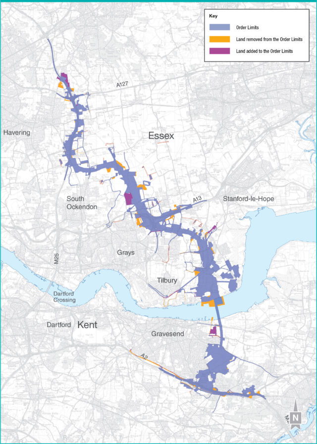
Two important ways in which our proposals have developed since our previous consultation relate to our proposed Order Limits and utilities works. These are summarised below.
Referred to in previous consultations as the development boundary, the Order Limits are the outermost edges of the Lower Thames Crossing project.
Since our last consultation, we have reduced the area within the revised Order Limits from 22.9km sq to 22.2km sq. We have also reduced the number of properties within the Order Limits to 130 from 150. Of these, 46 would only be affected by works to adjust existing overhead electricity power lines in the Linford area, and would not be acquired for the project.
Of the other properties in the Order Limits, 35 would need to be demolished and the remainder would be impacted by construction works or would need temporary or permanent changes to how they are accessed.
We have continued to work with utility companies to further refine our proposals for more than 100 utility works to enable the project to be built. Our emphasis has been on reducing the impact on communities, local landowners, businesses and the environment, while also working to minimise any visual impacts once the new road is open.
The Operations update and Map Book 2: Land Use Plans, provide further information, including:
- the realignment of gas pipelines to reduce impacts on woodland near to Brewers Road and the Orsett Showground
- the relocation of the Shorne Woods switchgear equipment
- changes to proposed electric substation locations, resulting in modifications to the proposed utility diversion routes, the Order Limits and our land requirements
Our ongoing discussions with utility companies have also enabled us to remove a number of areas of land from the Order Limits as they are no longer needed for utility diversions. These are detailed in chapter 3 of the Operations update (PDF 66MB).
To describe the changes, we have divided the route into several sections on both sides of the river:
- south of the river in Kent: A2/M2 corridor, south of Gravesend (A2/Cyclopark), south of the River Thames/southern tunnel entrance
- north of the river in Thurrock and Essex: Tilbury area, A13/A1089 junction, Mardyke Valley/North Road, M25/J29
A2/M2 corridor
- A gas pipeline would be located underneath Brewers Road and Park Pale instead of the land adjacent to the A2. This would reduce the impact on Ancient Woodland and the area of outstanding natural beauty.
- Following stakeholder feedback, the previous proposal, which required two crossings of the existing National Grid gas feeder pipeline, was revised to improve safety. The revised diversion route will avoid the need for the crossings. This reduces any risk to the pipeline, the workforce and the environment. This change means we will require permanent rights over a slightly larger area.
- Access to the Harlex Haulage business has been changed and a public right of way diverted to improve public safety.
- Relocation of Shorne Woods utility switching station from Thong Lane to the A226. The change would reduce visual impacts by removing the existing overhead power cables.
South of Gravesend (A2/Cyclopark)
- An electricity cable would be located either under, or next to, the footpath around the A2 Roman Road, from Valley Drive west to the B262 Hall Road to reduce the impact on this area.
South of the River Thames/southern tunnel entrance
- Works to install the temporary drainage pipeline from the Southern Tunnel Entrance Compound to the River Thames, would be carried out in a field behind the houses on the north side of Lower Higham Road. Access would be required via an existing entrance to the field from Lower Higham Road.
- We have included three arable fields in the Order Limits to the north of Chalk and to the south of the Thames and Medway Canal and Metropolitan Police firing range. Our proposed changes to how these fields are farmed will improve the habitat for birds during construction.
We have also provided a series of maps and images to show changes south of the river in Kent in chapter 3 of the Operations update (PDF 66MB).
Tilbury area
- We have extended the Order Limits to the south of Substation Road, where it passes between the existing power transmission site to the north and the site of the old Tilbury Power Station to the south. This would allow for a new power line to be placed underground and would reduce impacts on the utility companies.
- Two existing culverts on the Tilbury Main river to the east of the new road would be removed and a further culvert replaced with a larger structure.
- Vehicle access to a private wharf situated to the east of Port of Tilbury (Tilbury 2 terminal) and to the west of Coalhouse Fort has changed to a single vehicle crossing to limit the impact on the Two Forts Way public right of way.
- We have removed the East Tilbury Jetty to the east of Port of Tilbury (Tilbury 2 terminal) as any deliveries by river would come through the Port of Tilbury or other established port/dockside facilities.
- We have reduced the land required to accommodate a pipe to discharge surplus water into the river.
- An area of ecological mitigation land is no longer within our Order Limits following stakeholder feedback.
A13/A1089 junction
- A modification to the A13 junction, comprising an extra lane on the link road extending from where the road passes Baker Street through to the Orsett Cock roundabout to provide additional capacity.
- We have identified an alternative location for the restringing of overhead power lines north of Linford and reduced the area required within the Tarmac site but extended the Order Limits north east over vegetation and agricultural land.
- Changes to the route of utility diversions to the south of Stanford Road A1013 and an overall reduction in the Order Limits as we can locate the utilities along field boundaries.
- Extension of the Order Limits to fields to the east and west of the A1089 Dock Approach Road to ensure permanent access rights to the overhead line network.
- Following feedback received from landowners and the owners of Orsett Showground, the proposed replacement area for Orsett Showground has been removed from the Order Limits.
- We have reduced the Order Limits around the Ron Evans Memorial Field following changes to replacement open space proposals.
- Working with gas company, Cadent, we have refined the area to the north of the A13 between Rectory Road and Orsett Cock roundabout, to divert a high‑pressure gas pipeline. This allows a reduction of the Order Limits, reducing the impact at Orsett Showground and land currently being used for football pitches by Orsett Park Royals Football Club
Mardyke Valley/North Road
- The proposed replacement Orsett Fen common land has been reconfigured and the Order Limits amended.
- There has been an amendment to the landscape design associated with the Mardyke Crossing to provide a suitable ditch network and habitat for water voles.
- A refinement to the Order Limits, including an overall reduction around Ockendon Road/Pea Lane to avoid impacting existing vegetation.
- A flood relief channel would be built next to the Mardyke, at the western end of the proposed viaduct. A flood bund would be constructed to the west of where the new road would cross the Mardyke. There would be a reduction in the size of the compensatory flood storage area here.
- A reduction in the size of the compensatory flood storage area to the north of Green Lane.
M25/J29
- An extension of the Order Limits around St Mary’s Lane substation to include an existing substation, which some of our utility diversions will connect to.
- To avoid impacting a local business, the woodland planting and environmental mitigation proposals in the area to the north of J29 of the M25 and around Folkes Lane Woodland have changed.
- Access from Moor Lane east and from Laburnham Gardens is no longer needed due to the proposed introduction of access directly from the new J29 road.
We have also provided a series of maps and images to show changes north of the river in Thurrock and Essex in chapter 3 of the Operations update (PDF 66MB).
The Lower Thames Crossing would have an impact on special category land. This includes, but is not limited to, land that forms part of common and open space. The compulsory purchase of special category land, or of rights over this land, such as a right of access, is subject to specific statutory rules.
Our proposals for the new road and its construction would have both temporary and permanent impacts on eight open space sites and three common land sites.
Since the previous consultation, we have updated our proposals at five sites:
Shorne Woods Country Park
A small area of permanent rights would be required along the north of the A2 for ecological mitigation.
Cyclopark
We have reduced the impact on the Cyclopark by reducing the width of the land required for our works north of the A2.
Ron Evans Memorial Field
We propose to acquire two areas of replacement land to the south and west of the existing site. The replacement land would be landscaped and connected to the area of the memorial field to be retained to the north of Long Lane.
Orsett Fen – common land
We are now proposing to provide replacement land to the north and south of the existing common land. This replacement area would be designated as common land and benefit from the same rights of access and common rights as the existing and retained common land.
Thames Chase Community Forest
We have reduced the amount of replacement open space land, removing a previously proposed area of land on the eastern side of the M25. Now, all the proposed replacement land would be on the western side of the M25, situated north and south of the existing Thames Chase Community Forest.
We propose to acquire six areas of land to provide replacement open space and common land within the Order Limits. For these areas we will be providing 926,200m sq of replacement land, which is more than the 816,200m sq we are proposing to acquire.
These areas would be:
- Shorne Woods Country Park
- Tilbury Green
- Ron Evans Memorial Field
- Orsett Fen – common land
- Thames Chase Community Forest
- Folkes Lane Woodland
We will acquire land in accordance with the relevant provisions of sections 131 and 132 of the Planning Act 2008, which means we will provide replacement land which is no less in area than that which we propose to purchase and which will be no less advantageous to those, if any, entitled to rights of common or other rights, and to the public.
You can find further details, including a breakdown of replacement land provided in each area along with maps of these areas, in chapter 3 of the Operations update (PDF 66MB).
Further information on replacement land and the new open space sites can also be found in Map book 1 – General Arrangements (PDF 53MB).
In addition to impacting special category land, the new road would affect a number of private recreational facilities, as well as the Orsett Showground site. This is either because we propose purchasing all or part of those sites (or rights over those sites), or need to use the areas temporarily to build the new road.
Since the previous consultation, we have updated our proposals at three of these facilities.
Gravesend Golf Centre
The site consists of a nine‑hole pitch and putt golf facility with a driving range. We propose to permanently acquire part of the facility for the landscaped parkland around the southern tunnel entrance.
At our previous consultation, we said we were proposing to provide a replacement golf facility to the south‑east of the Cascades Leisure Centre, to enable the Gravesend Golf Centre business to continue. We are, however, engaging with Gravesham Borough Council and the current operator regarding a potential proposal to replace the golf facility on land within the site of the Cascades Leisure Centre, which is currently used as football pitches. That proposal, if agreed, would be delivered separately to the Lower Thames Crossing project.
If a golf facility is provided on that site, we would seek to provide football pitches on the land to the south‑east of the Cascades Leisure Centre, rather than provide a golf facility on that land as proposed at the design refinement consultation. If the potential proposal being discussed with Gravesham Borough Council is not implemented and a golf facility is not provided on that site, we will provide a replacement golf facility as previously proposed.
Linford Allotments
This land comprises approximately two hectares of land within the Order Limits and is required for the temporary construction and for permanent operation of an existing overhead electricity cable and a new corridor for several utilities.
Orsett Park Royals Football Club pitches
A field to the north west of Orsett Cock roundabout is currently being used by Orsett Park Royals Football Club for two football pitches and one smaller pitch. We are proposing to divert a gas pipeline to the south and east of the pitches. There may be some impact on the area currently used for the smaller pitch during the diversion works, which we will seek to mitigate.
We have also provided a series of maps and images to show changes to private recreational facilities in chapter 3 of the Operations update (PDF 66MB).
Highways England is committed to creating a positive green legacy. We are therefore proposing two new open space sites that would provide wider benefits to the community.
Since the design refinement consultation, we have continued to refine the design of one of these new open space sites, Tilbury Fields.
Chalk Park
Another new park, Chalk Park, is proposed on part of the Southern Valley Golf Club site, which would be permanently acquired. This would provide a recreational area for the public and create a desirable separation between the southern tunnel entrance and the eastern edge of Gravesend.
Within the new area, informal footpaths are proposed that would connect with existing public rights of way. When complete, Chalk Park would cover an area of around 38ha.
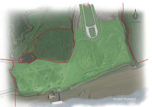
Tilbury Fields
A new park, Tilbury Fields, of around 45ha is being proposed on the northern banks of the River Thames, just west of the northern tunnel entrance.
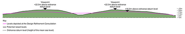
We are inviting feedback on two options for the height of the viewpoints in this park. The maximum height of the landform shown in this consultation is currently being developed in more detail with key stakeholders.
The design of Tilbury Fields will be developed to enhance the area’s unique character and ecology.
The previous design refinement consultation contained general arrangement drawings in Map Books 1 and 3, with potential highpoints. We have continued to evolve the design and are now exploring having highpoints of a range of different heights that could be up to 22.5 metres above ordnance datum level (height of the mean sea level) in the new area, to provide improved viewpoints over the estuary and nearby historic forts on both sides of the river.
The lower landform option as previously indicated at the design refinement consultation would be 16.5 metres above the ordnance datum level. The higher landform option would be up to six metres higher than previously indicated at the design refinement consultation and allow for improved views and more repurposing of material.